Tuesday 26 February 2013

A 1.5C Temperature Rise Would Set Off Siberia's Permafrost Carbon Bomb, Scientists Warn

Researchers led by experts from Oxford University warn that a 1.5C temperature rise would melt Siberia’s permafrost, which would in turn release hundreds of gigatonnes of stored carbon dioxide and methane into the atmosphere. Covering nearly a quarter of the northern hemisphere, this ticking carbon bomb would speed up global warming and cause widespread climate change. However, it would likely take a few decades for the permafrost to melt and therefore greenhouse gas emissions would initially trickle into the atmosphere. The researchers studied stalactites and stalagmites in Siberia that formed hundreds of thousands of years ago when temperatures rose. By cutting into the icy structures, the scientists were able to determine when their growth accelerated and slowed; they then compared this information to climate conditions at the time. Based on these measurements, they determined that the 400,000 year old cave formations in a far northern cave grew when temperatures were 1.5C higher than they were prior to the industrial revolution. But in places where there was only a 0.5-1.0C temperature rise, no such formations occurred, suggesting that 1.5C is “a tipping point,”.

“I would expect to see continuous permafrost start to thaw along the boundaries at this threshold of 1.5C [in future],” Anton Vaks, lead researcher from Oxford University. This melting and subsequent climate change would have a resounding impact on the surrounding environment, Vaks continued. Arid areas, including the Gobi Desert, could become much wetter, but more research must be done to establish the rate at which these changes are expected to occur.

Get lost in a stunning 320-gigapixel image of London

How well do you know the landmarks of London? Get up close and personal with a stunning 320-gigapixel image of the city captured atop the BT Tower.
Snapped by panorama experts 360Cities, the epic photography endeavor required the use of four Canon 7D dSLR cameras outfitted with some heavy-duty equipment.
Each camera used an EF 400mm f/2.8L IS II USM lens, Extender EF 2x III teleconverter, and a Rodeon VR Head ST robotic panorama head. After shooting 48,640 individual pictures over the course of three days (shortly after the 2012 Olympics), 360Cities spent the next several months assembling and stitching together the final gargantuan image.
If printed out on paper, the 320-gigapixel super shot would stretch out 323 feet wide and stand 77 feet tall -- nearly the same size as Buckingham Palace. I wonder how much that frame would cost.

Monday 18 February 2013

Hobbiton, Shire, New Zealand.This is the location where famous Hollywood trilogy Lord of the Rings was filmed.

The Shire is a region of J. R. R. Tolkien's fictional Middle-earth, described in The Lord of the Rings and other works. The Shire refers to an area settled exclusively by Hobbits and largely removed from the goings-on in the rest of Middle-earth. It is located in the northwest of the continent, in the large region of Eriador and the Kingdom of Arnor. Its name in Westron was Sûza "Shire" or Sûzat "The Shire". Its name in Sindarin was i Drann.

According to Tolkien, the Shire measured 40 leagues (193 km, 120 miles) from the Far Downs in the west to the Brandywine Bridge in the east, and 50 leagues (241 km, 150 miles) from the northern moors to the marshes in the south. This is confirmed in an essay by Tolkien on translating The Lord of the Rings, where he describes the Shire as having an area of 18,000 square miles (47,000 km2).
The original territory of the Shire was bounded on the east by the Baranduin River, on the north by uplands rising to the old centre of Arnor, on the west by the White Downs, and on the south by marshland south of the River Shirebourne. After the original settlement, hobbits also expanded to the east into Buckland between the Baranduin and the Old Forest, and (much later) to the west into the Westmarch between the White Downs and the Tower Hills.
The Shire was originally divided into four Farthings. The outlying lands of Buckland and the Westmarch were formally added after the War of the Ring. Within the Farthings there are some smaller unofficial clan homelands: the Tooks nearly all live in or near Tuckborough in Tookland, for instance. A Hobbit surname often indicates where the family came from: Samwise Gamgee's last name derives from Gamwich, where the family originated. Buckland was named for the Oldbucks (later called the Brandybucks).
The Shire is described as a small but beautiful and fruitful land, beloved by its inhabitants. The Hobbits had an extensive agricultural system in the Shire but were not industrialised. The landscape included small pockets of forest (again similar to the English countryside). Various supplies were produced in the Shire, including cereals, fruit, wood and pipe-weed. 
 
Hobbiton is a village along a stream locally known as The Water, a short distance west of Bywater. There are no stables, inns, or pubs in the town, the nearest of which are found in Bywater. The neighbourhood to the north, The Hill, is divided into Underhill on the south and Overhill on the north; The Hill Road runs north from Bagshot Lane and continues onward to Overhill.
On the north bank of the Water in Hobbiton was "The Mill", with a large water-wheel and a yard behind it. Sandyman the Miller owned the Mill and operated it with the help of his son Ted Sandyman. Lotho Sackville-Baggins had the Old Mill knocked down and the New Mill built in its place. The New Mill was an ugly red-brick building with a tall chimney. It was bigger than the Old Mill and full of wheels and strange contraptions to increase production. The New Mill straddled the Water and poured pollutants into the stream. It was operated by Men, and Ted Sandyman stayed on to help them. When Saruman came to the Shire in September 3019, the Mill was no longer used for grinding grain but for some industrial purpose; and loud noises, smoke, and filth issued from it. After Saruman was killed and the Chief's Men defeated at the Battle of Bywater, the New Mill was removed

Elevador da Bica, Lisbon, Portugal

The Bica Funicular  is a funicular in Lisbon, Portugal, that forms the connection between the Calçada do Combro/Rua do Loreto and the Rua de S. Paulo. It is operated by Carris.
The Bica funicular was opened on 28 June, 1892. It climbs the Rua da Bica de Duarte Belo for 245 metres from the Rua S. Paulo. The lower station of this funicular railroad is almost hidden behind a facade on the Rua de S. Paulo with the inscription "Ascensor da Bica". It was constructed by Raoul Mesnier de Ponsard and opened to the public in 1892.In 2002 it was designated a National Monument.

Spots & Exotics: Phugtal Monastery,Ladakh,India

Spots & Exotics: Phugtal Monastery,Ladakh,India: Phugtal Monastery or Phugtal Gompa (often transliterated as Phuktal ) is a monastery in south-eastern Zanskar, Ladakh in northern India...

Lake Huron

 Lake Huron  is one of the five Great Lakes of North America. Hydrologically, it comprises the easterly portion of Lake Michigan–Huron, having the same surface elevation as its westerly counterpart, to which it is connected by the wide Straits of Mackinac. It is bounded on the east by the Canadian province of Ontario and on the west by the state of Michigan in the United States. The name of the lake is derived from early French explorers who named it for the Huron people inhabiting the region. The huronian glaciation was named due to evidence collected from Lake Huron region.

By surface area, Lake Huron is the second-largest of the Great Lakes, with a surface area of 23,000 square miles (59,600 km2) making it the third-largest fresh water lake on Earth (and the fourth-largest lake, if the Caspian Sea is counted as a lake). By volume however, Lake Huron is only the third largest of the Great Lakes, being surpassed by Lake Michigan in this aspect. When measured at the Low Water Datum, the lake contains a volume of 850 cubic miles (3,540 km3) and a shoreline length (including islands) of 3,827 miles (6,157 km).
The surface of Lake Huron is 577 feet (176 m) above sea level. The lake's average depth is 195 feet (59 m), while the maximum depth is 750 feet (229 m).It has a length of 206 miles (332 km) and a greatest breadth of 183 miles (295 km).
Important cities on Lake Huron include: Goderich, Sarnia, Bay City, Alpena, Rogers City, Cheboygan, St. Ignace, and Port Huron.
A large bay that protrudes northeast from Lake Huron into Ontario, Canada is called Georgian Bay. A notable feature of the lake is Manitoulin Island, which separates the North Channel and Georgian Bay from Lake Huron's main body of water. It is the world's largest freshwater island.A smaller bay that protrudes southwest from Lake Huron into the state of Michigan, U.S.A. is called Saginaw Bay.

Drowned ship in lake Huron
More than a thousand wrecks have been recorded in Lake Huron. These purportedly include the first European vessel to sail the Great Lakes, Le Griffon built in 1679 on the eastern shore of Lake Erie, near Buffalo, New York, Sieur de la Salle navigated across Lake Erie, up the Detroit River, Lake St. Clair and the St. Clair River out into Lake Huron. Passing the Straits of Mackinac, La Salle and the Griffon made landfall on Washington Island, off the tip of the Door Peninsula on the Wisconsin side of Lake Michigan. Here, La Salle filled the Griffon with pelts and in late November 1679 sent the Griffon back to the site of modern day Buffalo, never to be seen again.
Two wrecks have been identified as the Griffon, although neither has gained final verification as the actual wreck. Blown by a fierce storm after leaving, the Griffon ran aground before the storm. The people of Manitoulin Island say that the wreck in Mississagi Straits at the western tip of the island is that of the Griffon. Meanwhile, others near Tobermory say that the wreck on Russell Island, 150 miles further east in Georgian Bay is that of the Griffin

Kauai, Hawaii

Kauaʻi or Kauai , known as Tauaʻi in the ancient Kauaʻi dialect, is geologically the oldest of the main Hawaiian Islands. With an area of 562.3 square miles (1,456.4 km2), it is the fourth largest of the main islands in the Hawaiian archipelago, and the 21st largest island in the United States.Known also as the "Garden Isle", Kauaʻi lies 105 miles (169 km) across the Kauaʻi Channel, northwest of Oʻahu. This island is the site of Waimea Canyon State Park.
The United States Census Bureau defines Kauaʻi as Census Tracts 401 through 409 of Kauaʻi County, Hawaiʻi, which is all of the county except for the islands of Kaʻula, Lehua, and Niʻihau. The 2010 census population of Kauaʻi (the island) was 67,091, with the largest town by population being Kapaʻa.

Kauaʻi's origins are volcanic, the island having been formed by the passage of the Pacific plate over the Hawaii hotspot. At approximately six million years old, it is the oldest of the main islands. The highest peak on this mountainous island is Kawaikini at 5,243 feet (1,598 m).
The second highest peak is Mount Waiʻaleʻale near the center of the island, 5,148 feet (1,569 m) above sea level. One of the wettest spots on earth, with an annual average rainfall of 460 inches (1,200 cm), is located on the east side of Mount Waiʻaleʻale. The high annual rainfall has eroded deep valleys in the central mountains, carving out canyons with many scenic waterfalls. On the west side of the island, Waimea town is located at the mouth of the Waimea River, whose flow formed Waimea Canyon, one of the world's most scenic canyons, and which is part of Waimea Canyon State Park. At 3,000 feet (914 m) deep, Waimea Canyon is often referred to as "The Grand Canyon of the Pacific". Kokeo Point lies on the south side of the island. The Na Pali Coast is a center for recreation in a wild setting, including kayaking past the beaches, or hiking on the trail along the coastal cliffs.

This Futuristic Building Design Comes from Zaha Hadid Architect


This futuristic building design is a complex of apartments, offices and leisure facilities proposed for an abandoned site in Belgrade, Serbia. The lot is only 500 meters from the city’s center, but is currently abandoned and unused. The design covers an area of 94,000 square meters and is called Beko Masterplan.

The Beko Masterplan will feature a five-star hotel, a congress center, galleries and stores. There will also be an underground parking lot. The main attraction of this futuristic building is the aesthetic design itself. It’s the kind of design that makes you stand back and say “we’ve officially reached ‘the future.’”

“The masterplan follows the region’s strong Modernist traditions and has applied new concepts and methods that examine and organize the programs of the site; defining a composition of buildings with the elegance of coherence that addresses the complexity of twenty-first century living patterns,” said Zaha Hadid.

The world's largest wind farm is coming!


Officials have unveiled plans to build the largest wind farm in the world. It will be built 10 miles off the coast of Fukushima.

Ever since the Fukushima nuclear disaster, Japan has been looking for new sources of energy to replace its nuclear reactors. This is no easy task, not only because nuclear power provided a significant fraction of the country's electricity, but also because if you just replace nuclear by fossil fuel power plants, you are trading one problem for another. Clean energy is the ideal substitute despite many challenges, but Japan is forging ahead!

Penitentes

These strange snow formations are called penitentes (or nieves penitentes). The tall, thin spikes are typically blade-shaped and can be found at high altitudes above 13,000 feet and are made of hardened snow or ice. The blades usually are oriented toward the sun.

It takes rather precise climatic conditions to produce penitentes.

In 2006, researchers were able to create penitentes in the lab, a first. The American Physical Society reports, "After some false starts, the apparatus that worked was a large horizontal freezer with a clear Plexiglas top. The team cooled the air by sending it through liquid nitrogen and also controlled humidity. They shined a flood lamp onto a block of snow or ice in the freezer and produced one- to five-centimeter
-tall spikes on the block within a few hours."

"Understanding their growth may give researchers insight into the process of glacier “evaporation” and may shed light on similarly-shaped micro-spikes that appear in materials like those in solar-powered energy cells," states the researchers. It may also help them in understanding how to preserve glaciers in a warming world.

HARLEY XL1200 BY CRD

Cafe Racer Dreams have made a name for themselves with classy Triumph and Honda customs. They’ve resisted the lure of Milwaukee so far, but as with most builders, there comes a time when you need to look at the Harley-Davidson Sportster.
The Harley brand is strong in Spain, but most customs are of the fringed leather variety. So CRD main man Pedro García decided to try a different approach, and at the same time, get the bike to corner well—by fitting 17” wheels. The result is CRD #21, nicknamed “The Stroke.” The base bike is a 2008 XL1200, but it’s now running a tank from Storz Performance. The seat is custom-made, and fitted onto a modified rear frame. Storz supplied the pipes too, with breathing enhanced on the inlet side by K&N filters. The suspension has been upgraded with Öhlins components and the controls and brakes are from Performance Machine. The headlight is now relocated well below the line of the bars, which sport LSL controls, and the foot controls are from Tarozzi. A complete repaint, including hand-lettering, finishes the job. The XL1200 now looks much more compact and muscular, with a nose-down visual stance and more focus on the engine. Is this the sort of Sportster that Harley themselves should be making, do you think?

Adastra Superyacht

Described by Boat International as "one of the world's most amazing super yachts, that could spell the future for efficient long range cruising", the striking 42.5m Trimaran Adastra has recently been launched in China for Hong Kong clients Anto and Elaine Marden.

"Adastra" is the result of meticulous attention to detail and innovative design to build a yacht that meets the needs of a very experienced ocean voyaging couple and their family, and to provide the level of comfort and style that would be expected in a yacht of this class and size. No effort has been spared in the challenge to produce a beautiful yacht that will have exceptionally low fuel consumption and yet provide excellent sea keeping qualities and luxurious accommodation. "Adastra" takes the power trimaran concept further than has ever been attempted before, previous vessels like "Earthrace" and "Cable and Wireless" were stripped out record breaking machines. The challenge of turning this concept into a viable luxury yacht has led us to further research and to develop new thinking on stability and comfort at sea for this type of craft. Extensive tank testing and radio controlled model tests in waves have been carried out to analyse stability and performance. Outrigger height has been optimised for ease of motion at sea, and a new outrigger shape has been developed to increase stability in waves. We have undertaken a state of the art structural analysis of all the major components in the yacht in order to achieve the light weight required for very low fuel consumption. All this has resulted in the exceptional vessel that was launched in China in April 2012.

Adastra's 16 metre beam creates a spacious saloon area on the main deck which offers superb views through a panoramic window and accommodates a lounge area, dining table and navigation station. A forward facing door through the saloon window gives easy access to a large sunbed on the foredeck. The aft deck has a sofa and bar area to port and a dining area to starboard, further aft of this there is space for a 4.9 metre tender and directly below is a garage which can store a 3.1 metre tender. The garage door has been designed to fold out and create a large dive platform. Extra space has been created below deck by slightly flaring the central hull just above the waterline. This area has been split into two sections with a full-width master cabin located aft with access from the deck saloon, and two further guest cabins, accommodation for the crew, and the galley located forward of the engine compartment. Adastra offers comfortable accommodation for nine guests and up to six crew members. The main helm station, which has seating for two, is positioned in a raised pilot house situated between the aft deck and the saloon area and forms part of the cross beam structure.

Extensive structural analysis of all parts of the yacht has been carried out, initially by White Young and Green and later by ASTA. This was the only viable way to analyse a shape and structure as complex as this. Simulations of loadings from side slamming, wave impact, and torsional effects of the outrigger riding through waves, were all applied to the computer model. The superstructure is carbon fibre with Nomex honeycomb core, the hull is glass/kevlar foam sandwich and the interior is light weight oak cabinetry using honeycomb panels. To help reduce weight, virtually every aspect of the boat is custom built. This includes carbon fibre hatches, portlights, ladders and even hinges, which are all built specifically for the vessel.

The anchoring system is unique with three anchors all driven by carbon fibre drum winches run by hydraulics. The primary anchor is a custom 130kg Bruce style anchor that deploys out of the starboard wing. The second anchor is 80kg and deploys out of the bow with a carbon fibre arm. The third anchor is 60kg which deploys out of the port wing and will be used as a stern anchor.

Saturday 9 February 2013

Urban forest

Urban forest, is a high commercial high-rise tower by MAD architects located in Chongqing, a major city in founder Yansong Ma’s home country of China. The proposal reiterate MAD’s design approach of syncing architecture with nature.
Aesthetically evocative on the mountainous landscape of the country, is made up of curved, abstracted shaped floors which have been layered slightly off-center from one another. Each level is afforded unaltered panoramic city views by the floor-to-ceiling glass, connected by a core cylindrical structure, which additionally conceals the core structure to deep within the space, each level’s interior is protected by full length glass windows with a see-through, wrap around balcony. As light enters the Urban Forest, it not only illuminates the spaces, but also becomes their visual structure, which provides transparency throughout the building, and makes the floors almost seem as if they are floating on top of one another. The extended floor plates form balconies which are infused with vegetation, courtyards, pools, and trees that serve as a connecting node for the urban form and environment, but the overall design brings together nature and the urban metropolis, with the incorporation of green space and large expansive views of the city.

Credits:
Architects: MAD Ltd
Location: Chongqing, China
Typology: Commercial, Office, Hotel
Site Area: 7,700 sqm
Building Area: 216,000 sqm
Building Height: 385 m
Structural Design: ARUP Group Ltd

Superyacht Adastra

One of the world's most amazing super yachts, that could spell the future for efficient long range cruising"
Boat International.The Adastra is so hi-tech that you can even control it with your Apple iPad within a 50 metre range.Its range is 4,000 miles, enough to go from the UK to New York in a single trip without refueling. With a length of 42m, it has a maximum speed of 22.5 knots, weighs in at 52 tonnes and has the capacity to host nine guests with room for up to six crew members. With her shiny body and smooth curves, this 17.55€-million superyacht is a real wealth symbol. Extensive structural analysis of all parts of the yacht has been carried out, initially by White Young and Green and later by ASTA. This was the only viable way to analyse a shape and structure as complex as this. Simulations of loadings from side slamming, wave impact, and torsional effects of the outrigger riding through waves, were all applied to the computer model.

Friday 8 February 2013

Emirates Stadium, home of Arsenal Football Club

Ashburton Grove, known for sponsorship reasons as the Emirates Stadium or simply The Emirates, is an association football stadium located in Islington, North London, England. It is the current home of Arsenal Football Club. At a capacity of 60,361, the Emirates is the third-largest football stadium in England after Wembley and Old Trafford and fourth-largest in the United Kingdom.
In 1997, Arsenal started exploring the possibility of relocating to a new stadium, having been denied planning permission by Islington Council to expand its then home ground of Highbury. After considering various options, the club settled on purchasing an industrial and waste disposal estate in Ashburton Grove and submitted their planning brief to the public in 2000. In spite of opposition to the move by local residents and club shareholders, Arsenal succeeded in winning the council's approval to which manager Arsène Wenger later described as being the "biggest decision in Arsenal's history" since the board opted to bring Herbert Chapman to the club in 1925.Estate relocation work began in August 2002 and commenced four months later. Financing for the stadium proved difficult, resulting in the club delaying work until February 2004. Emirates Airline was later announced as the main sponsor for the stadium in October 2004 and work reached completion in July 2006 at a cost of £390 million.
The stadium has undergone a process of 'Arsenalisation' beginning in August 2009, with the aim of restoring the club's heritage and history. The ground has frequently hosted music concerts and several international fixtures featuring the Brazil national football team.
In August 2009, Arsenal began a programme of 'Arsenalisation' of the Emirates Stadium after listening to feedback from supporters in a forum. The intention was to turn the stadium into a "visible stronghold of all things Arsenal through a variety of artistic and creative means", led by club CEO Ivan Gazidis.
Among the first changes were white seats installed in the pattern of the club's trademark cannon, located in the lower level stands opposite the entrance tunnel. "The Spirit of Highbury" – a shrine depicting every player to have played for Arsenal during its 93-year residence – was erected in late 2009 outside the stadium at the south end. Eight large murals on the exterior of the stadium were installed, each depicting four Arsenal legends linking arms, such that the effect of the completed design is 32 legends in a huddle embracing the stadium
Around the lower concourse of the stadium, further murals depicting 12 "greatest moments" in Arsenal history voted for by a poll on the club's website.Prior to the start of the 2010–11 season, Arsenal renamed the coloured seating quadrants of the ground as the East Stand, West Stand, North Bank, and Clock End.Akin to Highbury, this involved the installation of a clock above the newly renamed Clock End which was unveiled in a league match against Blackpool.
In April 2011, Arsenal renamed two bridges near the stadium in honour of club directors Ken Friar and Danny Fiszman. As part of the club's 125 anniversary celebrations in December 2011, Arsenal unveiled three statues of former captain Tony Adams, record goalscorer Thierry Henry and manager Herbert Chapman outside of the stadium.
The highest attendance for an Arsenal match at Emirates Stadium as of 2012 is 60,961, for a 2–2 draw with Manchester United on 3 November 2007. The average attendance for competitive first-team fixtures in the stadium's first season, 2006–07, was 59,837, with a Premier League average attendance of 60,045.The lowest attendance for an Arsenal match at Emirates Stadium as of 2012 is 46,539 against Shrewsbury Town in the Football League Cup third round on 20 September 2011, where Arsenal won 3–1.

Iguazu-falls, Brazil

Iguazu Falls, Iguazú Falls, Iguassu Falls or Iguaçu Falls are waterfalls of the Iguazu River on the border of Brazilian state Paraná and Argentine province Misiones. The falls divide the river into the upper and lower Iguazu. The Iguazu River rises near the city of Curitiba. It flows through Brazil for most of its course. Below its confluence with the San Antonio River, the Iguazu River forms the boundary between Argentina and Brazil.
The name "Iguazu" comes from the Guarani or Tupi words "y" , meaning "water", and "ûasú "[waˈsu], meaning "big". Legend has it that a god planned to marry a beautiful woman named Naipí, who fled with her mortal lover Tarobá in a canoe. In rage, the god sliced the river, creating the waterfalls and condemning the lovers to an eternal fall. The first European to find the falls was the Spanish conquistador Álvar Núñez Cabeza de Vaca in 1541.
There are two international airports close to Iguazú Falls: the Argentine Cataratas del Iguazú International Airport (IGR) and the Brazilian Foz do Iguaçu International Airport (IGU). Argentina's airport is 25 kilometres (16 mi) from the city of Iguazu but closer to the Falls hotels than its Brazilian counterpart. There is bus and taxi service from and to the Airport-Falls. Brazil's airport is between Foz do Iguaçu, Brazil and the falls. LAN Airlines and Aerolíneas Argentinas have direct flights from Buenos Aires to Iguazu International Airport Krause. Several Brazilian airlines, such as TAM Airlines, GOL, Azul, WebJet, offer service from the main Brazilian cities to Foz do Iguaçu.
Iguazu Falls experiences a subtropical climate with abundant precipitation and high temperatures year-round.

A look on Pienza

Pienza, a town and comune in the province of Siena, in the Val d'Orcia in Tuscany (central Italy), between the towns of Montepulciano and Montalcino, is the "touchstone of Renaissance urbanism."
In 1996, UNESCO declared the town a World Heritage Site, and in 2004 the entire valley, the Val d'Orcia, was included on the list of UNESCO's World Cultural Landscapes.
Pienza was rebuilt from a village called Corsignano, which was the birthplace (1405) of Aeneas Silvius Piccolomini , a Renaissance humanist born into an exiled Sienese family, who later became Pope Pius II. Once he became Pope, Piccolomini had the entire village rebuilt as an ideal Renaissance town. Intended as a retreat from Rome, it represents the first application of humanist urban planning concepts, creating an impetus for planning that was adopted in other Italian towns and cities and eventually spread to other European centers.
The rebuilding was done by Florentine architect Bernardo Gambarelli (known as Bernardo Rossellino) who may have worked with the humanist and architect Leon Battista Alberti, though there are no documents to prove it for sure. Alberti was in the employ of the Papal Curia at the time and served as an advisor to Pius. Construction started about 1459. Pope Pius II consecrated the Duomo on August 29, 1462, during his long summer visit. He included a detailed description of the structures in his Commentaries, written during the last two years of his life.

Lichtenstein Castle, Honau, Germany

Lichtenstein Castle is situated on a cliff located near Honau on the Swabian Alb, Baden-Württemberg, Germany.
Historically, there has been a castle on the site since around 1200. It was twice destroyed, once in the Reichskrieg's War of 1311 and again by the city-state of Reutlingen in 1381. The castle was not reconstructed and subsequently fell to ruin.
In 1802, the land came into the hands of King Frederick I of Württemberg, who built a hunting lodge there. By 1837, the land had passed to his nephew Duke Wilhelm of Urach, Count of Württemberg, who, inspired by Wilhelm Hauff's novel Lichtenstein , added the current castle in 1840–42. The romantic Neo-Gothic design of the castle was created by the architect Carl Alexander Heideloff.
Today, the castle is still owned by the Dukes of Urach, but is open to visitors. The castle contains a large collection of historic weapons and armour.

Montserrat, Catalonia- Spain

Montserrat  is a multi-peaked mountain located near the city of Barcelona, in Catalonia, Spain. It is part of the Catalan Pre-Coastal Range. The main peaks are Sant Jeroni (1,236 m), Montgrós (1,120 m) and Miranda de les Agulles (903 m). The mountain is the namesake for the Caribbean island of Montserrat.
It is well known as the site of the Benedictine abbey, Santa Maria de Montserrat, which hosts the Virgin of Montserrat sanctuary and which is identified by some  with the location of the Holy Grail in Arthurian myth.
"Montserrat" literally means "saw (serrated, like the common handsaw) mountain" in Catalan. It describes its peculiar aspect with multitude of rock formations which are visible from a great distance. The mountain is composed of strikingly pink conglomerate, a form of sedimentary rock. Montserrat is Spain's first National Park.
The Benedictine Abbey can be reached by road, by the Aeri de Montserrat cable car, or by the Montserrat Rack Railway. The lower stations of both the rack railway and the cable car can be reached by Ferrocarrils de la Generalitat de Catalunya train from Barcelona's Plaça d'Espanya station. From the abbey, the Funicular de Sant Joan funicular railway goes up to the top of the mountain, where there are various abandoned hovels in the cliff faces that were previously the abodes of reclusive monks, whilst the Funicular de Santa Cova descends to a shrine.
 The highest summit of Montserrat is called Sant Jeroni (Saint Jerome) and stands at 1,236 meters (4,055 feet) above sea-level. It is accessible by hiking trails which connect from the top entrance to the Sant Joan funicular, the monastery, or the base of the mountain.
The Cavall Bernat (1 111 m) is an important rock feature popular with climbers.

Lotus Flower ArtScience Museum in Singapore, architect Moshe Safdie

ArtScience Museum  is one of the attractions at Marina Bay Sands, an integrated resort in Singapore owned by the US Las Vegas Sands company. Opened on 17 February 2011 by Singapore's Prime Minister Lee Hsien Loong, it is the world's first ArtScience museum.
Although it has a permanent exhibition, ArtScience Gallery, the ArtScience Museum mainly hosts touring exhibitions curated by other museums.
The architecture is said be a form reminiscent of a lotus flower. It is designed by the architect Moshe Safdie.
Referred to as "The Welcoming Hand of Singapore" by Las Vegas Sands chairman Sheldon Adelson, the ArtScience Museum is anchored by a round base in the middle, with ten extensions referred to as "fingers". The design concept for each finger denotes various gallery spaces sporting skylights at the "fingertips" which are included as sustainable illumination for the curved interior walls.

Ducati 1098


After a track day accident, Alonzo Bodden got his Ducati 1098 customized by Anglada Originals. The result is a powerful, heavily upgraded performance bike packed with top-shelf components and given a brutal streetfighter style.

Thursday 7 February 2013

Star-Wars-Unique-Futuristic-Architecture-Design

Korean architects from the architectural office Heerim Architects, decided to make a little landscape in Baku. Their project of two hotels in the capital of Azerbaijan, will make a new life into the architectural ensemble of the city. It is likely that the project owner does not give rest to the laurels of the other oil powers shocking audiences extraordinary project, one of the hotels like the exhibition center project in the UAE by Rem Koolhaas. Both hotels are located on two neighboring islands of the Gulf and the Caspian Sea will be made inside the bay, barely touching the shoreline. Hotel Full Moon will have a disc shape and symbolize the full moon. Its appearance will vary depending on which side and what angle to look at it. Its height is planned to reach 158 meters, 35 floors will house 382 rooms. Her neighbor, Hotel Crescent, will have a arch shape and symbolize the crescent moon. It is several meters below the Full Moon, and rises to a height of 32 floors. Architecture in Baku recently absorbs global trends, although it is clear that the UAE she can not keep up, but the projects are quite conceptual, and please look at the beautiful architecture is much closer.

Tuesday 5 February 2013

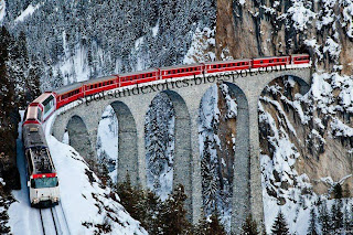
Graubunden, Switzerland

Glacier Express pulled by a Ge 4/4 III
Graubünden or Grisons is the largest and easternmost canton of Switzerland. The canton shares borders with the cantons of Ticino, Uri, Glarus and St. Gallen and international borders with Italy, Austria and Liechtenstein. The name Graubünden translates as the "Grey Leagues," referring to the canton's origin in three local alliances, the League of God's House, the Grey League, and the League of Ten Jurisdictions. Graubünden is also home to three of Switzerland's ethnic groups and the subsequent languages of Swiss German, Italian and Romansh are all native to the state. It is also the only canton where the Romansh language is still spoken.

Tropical Island Paradise- An Incredible Yacht Concept

Do you ever dreamed of exploring the surrounding world in your own boat? This fascinating tropical island yacht project is a dream come true for its designers, the UK based yacht design company Yacht Island Designs. Even though right now, it is still a concept. The brief for this dreaming yacht is to create an idyllic, floating island, with all the features of a tropical island getaway built into the design. With four VIP guest suites and a fascinating owner’s suite built into the volcano, the yacht is equipped with high-end features like a cinema, library, games room, gym and sauna. The exterior main deck includes the swimming pool, guest cabanas, the bar and outdoor dining. The waterfall can quite clearly been seen running from the volcano and feeding into the swimming pool. One of the more unique features of this yacht is the deploy-able beach deck which allows access to the sea for various water-sports and sea level relaxation.

Osaka City, Japan

Osaka is a city in the Kansai region of Japan's main island of Honshu, a designated city under the Local Autonomy Law, the capital city of Osaka Prefecture and also the largest part of the Keihanshin metropolis, which comprises three major cities of Japan, Kyoto, Osaka and Kobe. Located at the mouth of the Yodo River on Osaka Bay, Osaka is Japan's third largest city by population after Tokyo (special wards) and Yokohama.
Keihanshin is the second largest metropolitan area in Japan by population and one of the largest metropolitan areas highly ranked in the world, with nearly 18 million people,and by GDP the second largest area in Japan and the seventh largest area in the world.
Historically the commercial center of Japan, Osaka functions as one of the command centers for the Japanese economy. The ratio between daytime and night time population is 141%, the highest in Japan, highlighting its status as an economic center. Its nighttime population is 2.6 million, the third in the country, but in daytime the population surges to 3.7 million, second only after Tokyo (combining the Special wards of Tokyo, which is not a single incorporated city, for statistical purposes. See the Tokyo article for more information on the definition and makeup of Tokyo.) Osaka used to be referred to as the "nation's kitchen"  in feudal Edo period because it was the centre of trading for rice, creating the first modern futures exchange market in the world.

Monday 4 February 2013

Antelope Canyon at Arizona. Antelope Canyon is the most-visited and most-photographed slot canyon in the American Southwest.

Antelope Canyon is the most-visited and most-photographed slot canyon in the American Southwest.It is located on Navajo land near Page, Arizona. Antelope Canyon includes two separate, photogenic slot canyon sections, referred to individually as Upper Antelope Canyon or The Crack; and Lower Antelope Canyon or The Corkscrew.
The Navajo name for Upper Antelope Canyon is Tsé bighánílíní, which means "the place where water runs through rocks." Lower Antelope Canyon is Hazdistazí (advertised as "Hasdestwazi" by the Navajo Parks and Recreation Department), or "spiral rock arches." Both are located within the LeChee Chapter of the Navajo Nation.
Antelope Canyon is a popular location for photographers and sightseers, and a source of tourism business for the Navajo Nation. It has been accessible by permit only since 1997, when the Navajo Tribe made it a Navajo Tribal Park. Photography within the canyons is difficult due to the wide exposure range (often 10 EV or more) made by light reflecting off the canyon walls.
The road to Antelope Canyon is gated by the Navajo Nation and entry is restricted to guided tours led by authorized tour guides.Tours can be purchased in nearby Page, Arizona and range from $30 to $80 per person, depending on the time of the day and length of the tour.

Maldives

Maldives consists of 1,192 coral islands grouped in a double chain of 26 atolls, along the north-south direction, spread over roughly 90,000 square kilometres (35,000 sq mi), making this one of the world's most dispersed countries. It lies between latitudes 1°S and 8°N, and longitudes 72° and 74°E. The atolls are composed of live coral reefs and sand bars, situated atop a submarine ridge 960 kilometres (600 mi) long that rises abruptly from the depths of the Indian Ocean and runs north to south. Only near the southern end of this natural coral barricade do two open passages permit safe ship navigation from one side of the Indian Ocean to the other through the territorial waters of Maldives. For administrative purposes the Maldivian government organised these atolls into twenty one administrative divisions. The largest island of Maldives is Gan, which belongs to Laamu Atoll or Hahdhummathi Maldives. In Addu Atoll the westernmost islands are connected by roads over the reef (collectively called Link Road) and the total length of the road is 14 km (9 mi).
Maldives is the lowest country in the world, with a maximum natural ground level of only 2.4 metres (7 ft 10 in), with the average being only 1.5 metres (4 ft 11 in) above sea level, although in areas where construction exists, this has been increased to several metres. However, more than 80 per cent of the country's land is composed of coral islands that rise less than one metre above sea level.
The reef is composed of coral debris and living coral. This acts as a natural barrier against the sea, forming lagoons. Other islands, set at a distance and parallel to the reef, have their own protective fringe of reef. An opening in the surrounding coral barrier allows access to the calmer lagoon waters. The barrier reefs of the islands protect them from the storms and high waves of the Indian Ocean.
A 15 centimetres (6 in) thick layer of humus forms the top layer of soil. Below the humus layer are 60 centimetres (2 ft) of sandstone, followed by sand and then fresh water. Due to high levels of salt in the soil near the beach, vegetation is limited there to a few plants such as shrubs, flowering plants, and small hedges. In the interior of the islands, more vegetation such as mangrove and banyan grow. Coconut palms, the national tree, are able to grow almost everywhere on the islands and are integral to the lifestyle of the population.
The limited vegetation and land wildlife is supplemented by the abundance of marine life. The waters around the Maldives are abundant in rare species of biological and commercial value. Tuna fisheries are one of the main commercial resources. The Maldives have an amazing diversity of sea life, with corals and over 2,000 species of fish, ranging from reef fish to reef sharks, moray eels, and a wide variety of rays: Manta rays, Stingrays, and Eagle rays. The Maldivian waters also host whale sharks and hawksbill and green sea turtles.

Hang Nga Guesthouse a.k.a Crazy House - Vietnam

Hằng Nga guesthouse  popularly known as the “Crazy House” , is an unconventional building designed and constructed by Vietnamese architect Dang Viet Nga in Đà Lạt, Vietnam. Described as a “fairy tale house”, the building’s overall design resembles a giant tree, incorporating sculptured design elements representing natural forms such as animals, mushrooms, spider webs and caves. Its architecture, comprising complex, organic, non-rectilinear shapes, has been described as expressionist. Nga has acknowledged the inspiration of Catalan architect Antoni Gaudí in the building’s design, and visitors have variously drawn parallels between it and the works of artists such as Salvador Dalí and Walt Disney. Since its opening in 1990, the building has gained recognition for its unique architecture, being highlighted in numerous guidebooks and listed as one of the world’s ten most “bizarre” buildings in the Chinese People's Daily.

To help alleviate the financial burden associated with what was essentially a personal project—having accumulated upwards of VND 30 million in debt—Nga expanded the building into a guesthouse, and opened the house to paid visits by tourists in late 1990.As of 2010, fees for visits to the guesthouse were VND 35,000 per visit; room rates ranged from VND 290,000 to 630,000 per room per night for Vietnamese, and from $29–63 for foreigners

Velassaru

Velassaru is a spectacular luxury resort in the middle of the Indian Ocean. Located on a private Island in the Maldives, the incredible Velassaru offers several water bungalows, villas, and suites perched above the crystal clear lagoon, and features sand as white as sugar. A magic place to escape the crazy pace of everyday life.

The Electric Car Ferry by Siemens is the First of Its Kind

The name of the Electric Car Ferry may be a bit deceiving. No, it is not a ferry for electric cars. Instead, it is an electric ferry that carries automobiles and other road vehicles. The first of its kind, it will replace the old gas guzzlers used in Norway. Known for their complex system of ferries, one route of which can burn up to 1 million liters of diesel per year, the Electric Car Ferry could make a vast difference.

Created by Siemens, the Electric Car Ferry has been designed as a catamaran so as to minimize water resistance and weigh less than typical vessels. Thus the electric engine requires about half of the standard diesel-fueled ones. Siemens nevertheless reveals that "the crucial feature of the new ferry is that it only takes 10 minutes to recharge the batteries." It will take to the waters in 2015.

A Completely Insane Panorama From The Top Of The World's Tallest Building

This is the view from the tallest man-made structure in the world, the Burj Khalifa in Dubai. Photographer Gerald Donovan set up a tripod at the top (2,722 feet) and took 48 panoramic images, each with an 80-megapixel resolution. The images were stitched together to create one seamless image, and presto: arguably one of the most amazing views ever, in a full 360 degrees.
You can rotate and zoom to explore Dubai in the shot. Unfortunately, you can't see people very easily. (Forget "the people look like ants from up here": some other buildings look like ants from this view.) And if that zooming gives you vertigo, just be thankful you weren't the photographer.

Scientists Find First Evidence Of Life In Antarctic Lake

Alien Ground Scientists could use microbes found in Vostok, Whillans and ellsworth, three subglacial lakes in Antarctica, to create DNA probes and biosignature models to be used by future search-for-life missions in our solar system Kevin Hand
But we've seen this before. Some more tests are needed to confirm it.
One of a few research teams hoping to find life in Antarctica seems to be a little closer to success. As Discover reports, the researchers at the subglacial Lake Whillans has taken a sample, and preliminary tests say they've found life!

Now for the caveat: It's important to focus on the word preliminary here. Nothing's conclusive just yet. DNA-sensitive dye made cells in a sample glow green when placed under a microscope, but we've seen that sort of thing before: Last year, other Antarctic researchers thought they had found life, only to discover that it was actually bacteria from their own kerosene supplies. Dead cells can show up in the researchers' test, too, so to make it official, they'll have to work through more time-intensive tests, where the cells grow.

If the team does discover life, it's big news for space exploration. The reason so many teams have been clamoring to find life in Antarctica is because the moons of Jupiter and Saturn are similar environments. If we know how to find life in our backyard, we might be able to find it in outer space.

Sunday 3 February 2013

Catherine Palace, St. Petersburg -Russia

The Catherine Palace is a Rococo palace located in the town of Tsarskoye Selo (Pushkin), 25 km south-east of St. Petersburg, Russia. It was the summer residence of the Russian tsars.
Although Stasov's and Cameron's Neoclassical interiors are superb manifestations of late 18th-century and early 19th-century taste, the palace is best known for Rastrelli's grand suit of formal rooms known as the Golden Enfilade. It starts at the spacious airy ballroom, the "Grand Hall" or the "Hall of Lights", with a spectacular painted ceiling, and comprises numerous distinctively decorated smaller rooms, including the reproduced Amber Room.
The Great Hall, or Light Gallery, as it was called in the 18th century, is a formal apartment in the Russian baroque style designed by Bartolomeo Rastrelli between 1752 and 1756. The Great Hall was intended for more important receptions such as balls, formal dinners, and masquerades. The hall was painted in two colors and covers an area of approximately 1,000 square meters. Occupying the entire width of the palace, the windows on the eastern side look out onto the park while the windows of the western side look out to the palace plaza. In the evening, 696 lamps are lit on 12-15 chandeliers located near the mirrors. The hall's sculptural and gilded carvings and ornamentation were created according to sketches by Rastrelli and models by Johann Franz Dunker.
Beyond the Great Hall is the dining room for the courtiers in attendance (the Courtiers-in-Attendance Dining Room). The room was designed by Rastrelli in the mid-18th century. The small room is lit by four windows which look out into the formal courtyard. The architect placed false windows with mirrors and mirrored glass on the opposite wall, making the hall more spacious and bright. Decorated in the typical baroque interior style, the hall is filled with gilded wall-carvings, complex gilded pieces on the doors, and ornamental patterns of stylized flowers. The ceiling mural was painted by a well-known student of the Russian School from the mid-18th century. It is based on the Greek myth of the sun god Helios and the goddess of the dawn, Eos.
Across from the Courtiers-in-Attendance Dining Room, on the other side of the Main Staircase, is the White Formal Dining Room. The hall was used for the empresses' formal dinners or "evening meals". The walls of the dining hall were decorated with the utmost extravagance with gilded carvings. The furnishings consist of gilded carvings on the consoles. The painted mural, The Triumph of Apollo is a copy of a painting completed in the 16th century by Italian artist, Guido Reni.
The Portrait Hall is a formal apartment covering 100 square meters. The room's walls boast large formal portraits of Empress Catherine I and Empress Elizabeth Petrovna, as well as paintings of Natalya Alexeyevna, sister of Peter the Great, and Empress Catherine II. The inlaid floors of the hall contain precious woods. The Drawing Room of Alexander I was designed between 1752 and 1756 and belonged to the Emperor's private suite. The drawing room stood out from the rest of the formal rooms in the palace due to the fact that the walls were covered in Chinese silk. Other decor in the room was typical for the palace's formal rooms−a ceiling mural and gilded carvings. The elegant card tables and inlaid wood commode display Japanese, Chinese, and Berlin porcelain.
The Green Dining Room, which replaced Rastrelli's "Hanging Garden" in 1773, is the first of the rooms in the northern wing of the Catherine Palace, designed by Cameron for the future Emperor Paul and his wife. The room's pistachio-coloured walls are lined with stucco figures by Ivan Martos. During the great fire of 1820 the room was seriously damaged, thus sharing the fate of other Cameron interiors. It was subsequently restored under Stasov's direction.

Blausee - Blue Lake, Kandersteg, Switzerland.

Blausee is a small lake in the Kander valley above Kandergrund at 887 m, near the river Kander. Administratively, it belongs to the Bernese Oberland. The lake has an area of 0.64 ha. The lake can be reached by bus from the train stations of Frutigen or Kandersteg. It is a popular tourist destination.

Saturday 2 February 2013

Boldt Castle, Heart Island, New York State- USA

Boldt Castle, located on Heart Island (New York) in the Thousand Islands of the Saint Lawrence River, along the northern border of New York State, is a major landmark and tourist attraction in its region.
Today, Boldt Castle is accessible by ferry from Alexandria Bay; Gananoque, Ontario; Rockport, Ontario; and Ivy Lea, Ontario; and most of the grounds and buildings can be explored by the public for a fee. The boat-owning public may also dock at Heart Island for free. There is a U.S. Customs and Border Protection office (wood structure manned by single customs officer) on Heart Island and visitors coming from Canada require appropriate identification, as visiting the island is considered entering the United States.
Most of the rooms on the first floor and many of the rooms on the second floor of Boldt Castle are furnished as of 2011, but mostly with modern pieces. The basement is mostly unfinished, with a pool, bowling lanes, many compartments, and a long passage to the Power House. Most of the rooms from the second floor to the top floor have been left unfurnished, but there are exhibits in some of these rooms and hallways showing pictures and artifacts of the Thousand Islands region during the era in which the Boldts lived. These rooms are also left unfurnished to give the visitor an opportunity to imagine what the castle looked like before modern improvement. At the edge of the island, a monument stone triumphal arch, originally intended by George Boldt to be the entrance way for boats, has been fully restored. The bridge connecting the two sides would have been raised and lowered as required.
Two other buildings on the island are the Power House and the Alster Tower; both are open to the public. The Power House was built to hold a generator to supply the island with power, and now is more of a museum of how electric power was obtained in the early 1900s, as well as a few stories of getting tools and equipment to Heart Island during the castle's construction. The Alster Tower was purposely constructed with slanting and uneven walls, ceilings, and roofs.
The huge George C. Boldt Yacht House on nearby Wellsley Island is unique, warranting a visit by means of another small fee and a shuttle boat connecting it to Heart Island. It was listed on the National Register of Historic Places in 1978.

Alfa Romeo to return Stateside in late 2013, promises Fiat CEO Sergio Marchionne

You can forget about your savings account and your loved ones now, Alfa is coming back to the US this year.
Just last week, we reported that Mazda and Alfa Romeo were teaming up to build the next Alfa Spider in 2015, which will be based on the next-generation Mazda MX-5. It was intended for a global market, but we were still wary that Fiat-owned Alfa brand would actually offer it Stateside, as the brand has yet to return to the US. Now, however, our hopes seem to be coming true, once again.
Reuters is reporting that Fiat CEO Sergio Marchionne has confirmed the return of Alfa Romeo for the US market in late 2013. In an interview with Reuters, Marchionne explained, “Its [sic] ready in the sense that a lot of work has gone on in terms of architectures and models. We’ve got to make sure we hit the powertrains dead on. This remains my key objective right now.”
Alfa has been struggling with sales in Europe and elsewhere as of late. Marchionne hopes that Alfa could upend its current sales track with the launch of the 4C sports car in late 2013 for the American market followed by the Giulia for 2014 and the Mazda-built Spider for 2015.
Alfa Romeo was last imported to the US in 1995. Since Fiat’s acquisition of Chrysler in 2009, Marchionne has been promising Alfa’s American return. Even as recently as last week, Marchionne had said that Alfa wasn’t ready for a US revival. Apparently things have changed in the last few days.
We’re unbelievably excited by the promise of the return of Alfa. Sure, its cars might not be very reliable but as Jeremy Clarkson has always said, “You can’t be a true petrolhead (the British version of gearhead) until you’ve owned an Alfa Romeo.” And as true petrolheads, we aim to own an Alfa here in the states as soon as possible even if it will break our hearts and wallets.

Dolomites Mountains, Italy

The Dolomites  are a mountain range located in north-eastern Italy. It is a part of Southern Limestone Alps and extends from the River Adige in the west to the Piave Valley (Pieve di Cadore) in the east. The northern and southern borders are defined by the Puster Valley and the Sugana Valley (Val Sugana). The Dolomites are nearly equally shared between the provinces of Belluno, South Tyrol and Trentino.
There are also mountain groups of similar geological structure that spread over the River Piave to the east – Dolomiti d'Oltrepiave; and far away over the Adige River to the west – Dolomiti di Brenta (Western Dolomites). There is also another smaller group called Piccole Dolomiti (Little Dolomites) located between the provinces of Trentino, Verona and Vicenza .
One national park and many other regional parks are located in the Dolomites. In August 2009, the Dolomites were declared a UNESCO World Heritage Site.
A tourist mecca, the Dolomites are famous for skiing in the winter months and mountain climbing, hiking, climbing and Base Jumping, as well as paragliding and hang gliding in summer and late spring/early autumn. Free climbing has been a tradition in the Dolomites since 1887, when 17-year-old Georg Winkler soloed the first ascent of the pinnacle Die Vajolettürme. The main centres include: Rocca Pietore alongside the Marmolada Glacier, which lies on the border of Trentino and Veneto, the small towns of Alleghe, Falcade, Auronzo, Cortina d'Ampezzo and the villages of Arabba, Urtijëi and San Martino di Castrozza, as well as the whole of the Fassa, Gardena and Badia valleys.
In the first week in July, the Maratona dles Dolomites, an annual single-day road bicycle racing race covering seven mountain passes of the Dolomites, is staged.

Bora Bora

Bora Bora is an island in the Leeward group of the Society Islands of French Polynesia, an overseas collectivity of France in the Pacific Ocean. The island, located about 230 km (140 mi) northwest of Papeete, is surrounded by a lagoon and a barrier reef. In the centre of the island are the remnants of an extinct volcano rising to two peaks, Mount Pahia and Mount Otemanu, the highest point at 727 m (2,385 ft).
Bora Bora is a major international tourist destination, famous for its aqua-centric luxury resorts. The major settlement, Vaitape, is on the western side of the main island, opposite the main channel into the lagoon. Produce of the island is mostly limited to what can be obtained from the sea and the plentiful coconut trees, which were historically of economic importance for copra. According to a census performed in 2008, the permanent population of Bora Bora is 8,880.
An Amazing Pool At Resort, Bora Bora
Today the island is almost entirely dependent on tourism. Over the last few years several resorts have been built on motu (small islands, from Tahitian) surrounding the lagoon. Thirty years ago, Hotel Bora Bora built the first over-the-water bungalows on stilts over the lagoon and today, over-water bungalows are a standard feature of most Bora Bora resorts. The quality of those bungalows ranges from comparably cheap, basic accommodations to very luxurious and expensive places to stay. The only camping on the island is Bora Bora Camping at the southern point of Motu Piti Aau.
Most of the tourist destinations are aqua-centric; however it is possible to visit attractions on land such as WWII cannons. Air Tahiti has five or six flights daily to the Bora Bora Airport on Motu Mute from Tahiti (as well as from other islands). The island is served by Bora Bora Airport on Motu Mute in the north, with Air Tahiti providing daily flights to and from Papeete on Tahiti.
Although French and Tahitian are the main languages spoken by the inhabitants, people in contact with tourists generally have some command of English. Most visitors to Bora Bora are American, Japanese, or European. Public transport on the island is non-existent. Rental cars and bicycles are the recommended method of transport. There are also small fun-cars for hire in Vaitape. Snorkeling and scuba diving in and around the lagoon of Bora Bora are popular activities. Many species of sharks and rays inhabit the surrounding body of water. There are a few dive operators on the island offering manta ray dives and also shark-feeding dives.
In addition to the existing islands of Bora Bora (called motu), the new man-made motu of Motu Marfo has been added in the north-eastern corner of the lagoon on the property of the St. Regis Resort.

Kashmir Valley

Icy River In Kashmir Valley, India
The Kashmir Valley  or Vale of Kashmir is a valley located between the Karakoram and the Pir Panjal Range in the Indian state of Jammu and Kashmir. No part of the valley lies in the area currently administered by Pakistan. It is around 135 km long and 32 km wide, formed by the Jhelum River. Kashmir Valley is one of the three administrative divisions in Jammu and Kashmir state and consists of Anantnag, Baramulla, Budgam, Bandipore, Ganderbal, Kupwara, Kulgam, Pulwama, Shopian and Srinagar districts.
Mughal emperor Jahangir called it "Paradise on Earth."

Kashmir valley is a popular tourist destination for domestic (Indian) and foreign tourists. Among the popular tourist places in the valley are Gulmarg that has a ski resort, Dal Lake that has popular house boats, Pahalgam and Amarnath Temple.
Before insurgency intensified in 1989, tourism formed an important part of the Kashmiri economy. The tourism economy in the Kashmir valley was worst hit. Thousands of Hindu pilgrims visit holy shrine of Amarnath every year and this significantly benefits the state's economy. But this yatra has put Kashmir on the verge of ecological disaster .
Tourism in the Kashmir valley has rebounded in recent years and in 2009, the state became one of the top tourist destinations of  Gulmarg, one of the most popular ski resort destinations in India, is also home to the world's highest green golf course.However with the decrease in violence in the state has boosted the states economy specifically tourism. It was reported that 736,000 tourists including 23,000 foreigners visited Kashmir in 2010.