Tuesday, 22 January 2013

Havasu Falls

Havasu Falls is a waterfall in the Grand Canyon located 1½ miles from Supai. It is arguably the most famous and most visited of all the falls and consists of one main chute that drops over a 120-foot (37 m) vertical cliff into a large pool. Due to the high mineral content of the water, the falls are ever-changing and sometimes break into two separate chutes of water.
The falls are known for their natural pools, created by mineralization, although most of these pools were damaged or destroyed in the early 1990s by large floods that washed through the area. A small man-made dam was constructed to help restore the pools and to preserve what is left. There are many picnic tables on the opposite side of the creek, and it is very easy to cross over by following the edges of the pools. It is possible to swim behind the falls and enter a small rock shelter behind it.

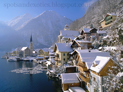
Hallstatt,Austria

Hallstatt, Upper Austria, is a village in the Salzkammergut, a region in Austria. It is located near the Hallstätter Sea (a lake). At the 2001 census, it had 946 inhabitants. Alexander Scheutz has been mayor of Hallstatt since 2009.
Hallstatt is known for its production of salt, dating back to prehistoric times, and gave its name to the Hallstatt culture, a culture often linked to Celtic, Proto-Celtic and pre-Illyrian peoples in Early Iron Age Europe, c.800-450 BCE. Some of the earliest archaeological evidence for the Celts was found in Hallstatt.
Situated in the south-western shore of the Hallstätter See, the town lies in the geographical region of Salzkammergut, on the national road linking Salzburg and Graz.

Salt was a valuable resource, so the region was historically very wealthy. It is possible to tour the world's first known salt mine, located above downtown Hallstatt.
The village also gave its name to the early Iron Age Hallstatt culture and is a World Heritage Site for Cultural Heritage. Hallstatt is a popular tourist attraction owing to its small-town appeal and can be toured on foot in ten minutes.

On 16 June 2011 plans to build a replica in China were first reported.On 2 June 2012, it was reported that Chinese mining company China Minmetals Corporation built a full-scale replica of the entire town in Huizhou, Guangdong province.

Monday, 21 January 2013

Transparent housing concept by Santambrogiomilano

The transparent housing concept by Santambrogiomilano, named Simplicity, are designed to be built almost in any place, allowing to be completely immersed in nature.All the component of the transparent housing concept, is composed of structural glass pieces.

There are two types, the ‘snow house’ located in colder climate, and the ‘cliff house’ with thinner lighter glass elements.

The special glass panels instantly turn matte only with the touch of a button.

According to designers:

Simplicity is when, in the act of creating the dwelling, matter becomes transparent, a medium for aesthetic values, the stage and theater of representation. Carlo Santambrogio and Ennio Arosio pursue and achieve their design intention in which glass figures as the unquestioned protagonist, excluding the mediation of supports that would challenge its leading role.

“That image is symbolic,” they comment. “We’re portrayed standing on a transparent sheet of glass. We’re on the upper floor of the Milan showroom, in reality absorbed into a dimension which effaces every distinction between spaces and relates the interior to the setting outside, the urban context. So often, at least virtually, the boundary line vanishes, and we receive the impression of an unbroken vision. It is then that we ask ourselves about the applications most relevant to the project. And we realize everything is possible in Simplicity, everything can be achieved, provided it embodies a sensitive interpretation of the basic function aimed at satisfying aesthetic needs. The Plexiglas joint makes it possible to combine and assemble the sheets of glass, defining architectural works which are one the development of the other and are integrated in and adapted to the most disparate settings.”

Tianjin Ecology and Planning Museum by Steven Holl Architects, in the new city being constructed near Tianjin, China.

The Ecology and Planning Museums will be 600,000 square feet. Will be the first institutions to be constructed in the cultural center of the new city. The city will be home to an estimated population of 500,000 when complete. “The Ecology Museum experience begins with an orientation projection space next to a restaurant and retail opening to the ground level. From there, visitors take the elevator to the highest exhibition floor. Visitors proceed through the three ecologies in a descending procession of ramps: Earth to Cosmos, Earth to Man, Earth to Earth. At the ground floor, the Earth to Earth Exhibition turns clockwise, moving down towards the Ocean Ecology Exhibition located under the reflecting pond of the plaza. Four outdoor green roof terraces open out from Level 2 (Earth to Earth) with living exhibits changing with the seasons.”

XLDron M Gravity designed for Space Tourism

The futuristic designed XLDron M Gravity is a conceptual vehicle by Oscar Vinals for space tourism, which is in its infancy, but its clear that it will grow.The XLDron M Gravity ship consists of two parts: an unmanned rocket booster (the XLDron) and a docking station (the M Gravity). The booster would be used to get travelers into orbit. Once the appropriate altitude is reached, Vinals says 65,000 feet should do, the M Gravity pops off of the XLDron and fires up its own engines to reach space. The ship would only be capable of cruising the cosmos for a short amount of time before it would need to be docked again

Sunday, 20 January 2013

Scientists uncover massive river on Mars!!

In 2012, the European Space Agency discovered a huge 1,500 kilometer river in the upper Reull Vallis region of Mars. The agency’s Mars Express took a picture of the area using a high-stereo camera, which gave an impressive look at the landscape. Now it has released the 3D image taken of the river, which shows a large area of the Reull Vallis complete with one tributary and mountains off to the right. According to scientists, the river was likely formed by water in the Hesperian period between 1.8 and 3.5 million years ago. Although only one is visible in the image, multiple tributaries meet the river, with the one pictured branching off in the main valley and re-merging upstream. The part of the river pictured is nearly 300 meters deep and 7 kilometers wide.

Visible to the right of the river and tributary are the Promethei Terra Highlands, which include the almost putty-like mountain ranges that appear hyper-smooth and rounded. The mountains are about 2,500 meters above the land’s surface, and are surrounded by impact craters, one of which has a diameter nearly are large as the mountain it is near. The scientists note that the river contains elements reminiscent of what you would find on Earth, with “step-like structures” in the craters indicating high water. Likewise, the morphology indicates that the area experienced glacial activity in its past, and provide the researchers with a relatively detailed look at events in the Red Planet’s past that helped shape it.

Algerian Abstract

Earth from sky!
Algerian Abstract
What look like pale yellow paint streaks slashing through a mosaic of mottled colors are ridges of wind-blown sand that make up Erg Iguidi, an area of ever-shifting sand dunes extending from Algeria into Mauritania in northwestern Africa. Erg Iguidi is one of several Saharan ergs, or sand seas, where individual dunes often surpass 500 meters (nearly a third of a mile) in both width and height. This image was acquired by Landsat 5 on April 8, 1985.